It's Tuesday, February 24. Today's emoji forecast: ❄️🔜 Snow chances are coming soon. Jon Rivas has your forecast. What people are talking about: |
|
|
TOP STORY: From Iowa to Africa |
|
|
4 THINGS YOU NEED TO KNOW |
|
|
🚨 Urbandale death investigation: Urbandale police are looking into what caused the death of a person found near an apartment complex. Read more 🚓 Iowa crime: An Iowa man is facing charges after he admitted during a job interview with a sheriff's office that he had accessed child pornography online. Read more 🎤 State of the Union: President Donald Trump will deliver his first State of the Union of his second term tonight. Read more ☎️ Variety telethon: KCCI is partnering with Variety the Children's Charity of Iowa for the 52nd annual Variety Telethon on Tuesday, bringing viewers a day of inspiring stories that highlight the power of community, inclusion, and hope. Read more |
|
|
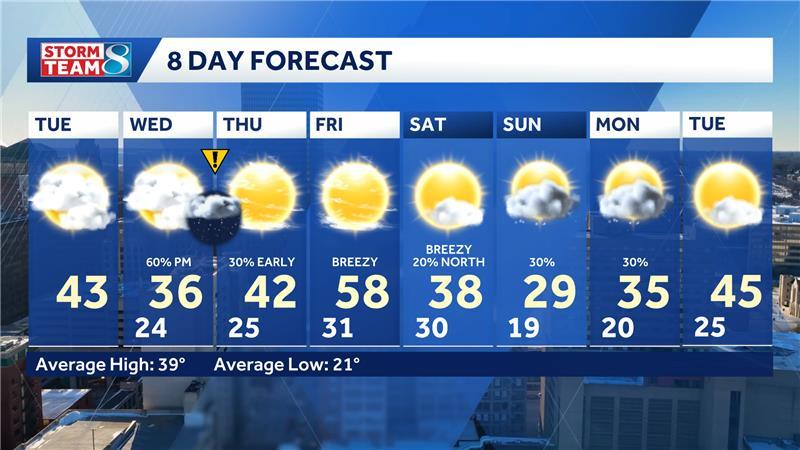
We are trending warmer for today, but it will still be an overall chilly afternoon for the areas that still have snow on the ground. Highs will range in the 30s and 40s for snow packed areas but snow free spots will climb into the 50s for this afternoon. There will be a southwest breeze ranging from 10 to 15 mph that will aid the temperature rebound for today under mostly cloudy skies.
Wednesday will start off partly cloudy with increasing clouds through the morning and into the afternoon. We will have our next chance for snow moving in for the midafternoon, setting up for some wet flakes possible for the evening commute. This is setting up to be another narrow band of snow with much lower accumulations compared to last week's snowstorm. Either way, the band will have the capability to produce 1 to 3 inches of snow with most of the impacted areas seeing .5 to 1.5 inches. This band is expected to set up over the northern half of the state where central Iowa is situated on the edge as accumulations are expected to stay under an inch for the metro. The path can still adjust as we get closer to late Wednesday, so stay up to date on air and online.
The snow will come to and end Thursday morning before rush hour, but we could still have some slick areas. We will begin our rebound again with highs climbing not the 50s Friday afternoon and even 60s for areas with no snow on the ground. The warmer temps do not last with a breezy cooldown come Saturday. This will also bring in additional snow chances for the weekend with the best chances Sunday and Monday. DAY BY DAY: |
- Today: Partly to mostly cloudy skies. High 43F. Winds shifting from SW to NW at 10 to 15 mph. Gusts up to 20 mph.
- Wednesday: Morning sunshine, then increasing clouds. Snow possible later in the afternoon, then evening. High near 36F. Winds N at 5 to 10 mph.
- Thursday: Mostly sunny. High 42F. Winds S around 10 mph.
- Friday: Mostly sunny. High 58F. Winds shifting from SW to NW at 10 to 15 mph. Gusts up to 20 mph.
|
|
|
Terms of Use | Privacy Notice
You received this email because you signed up for newsletters from KCCI
To stop receiving emails, unsubscribe ©2025 Hearst Television Inc.
300 W 57th Street, New York, NY 10019 |
|
|
|








No comments:
Post a Comment
Keep a civil tongue.